SUBHEAD: A break in the ability to move traffic back and forth over the Wailua River would cut the island in two.
By Juan Wilson on 26 August 2012 for Island Breath -
(http://islandbreath.blogspot.com/2012/08/wailua-beach-under-water.html)
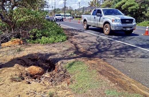
Image above: A hole at the edge of Kuhio Highway opposite the Coco Palms hotel has started to appear in the vicinity where the waves are undermining an ironwood tree. From (http://thegardenisland.com/news/local/people-see-the-changing-face-of-wailua-beach/article_9614b31a-ecfd-11e1-bccc-001a4bcf887a.html).
There is a shoreline crisis at the mouth of the Wailua River. It may be part of a cyclical event but there are inevitable forces that point to a deteriorating situation at this critical point of traffic circulation that the whole island of Kauai depends on. Over the last several years the state Department of Transportation and the County of Kauai have spent tens pf millions of dollars to "fix" the traffic problems and add a bike path amenity.
The widening of the cane haul bridge over the river cost $29 million alone. Those investments may be a total loss in the next decade. The beach has eroded dramatically and now threatens the highway. The planned bike path between the highway and the beach may be unbuildable. Unfortunately, the huge amount of energy and fortune spent to widen the Kuhio Highway should never have been spent so close to the ocean. In a Garden Island News article on 8/22/12 titled "The Changing Face of Wailua Beach", it was reported:
Had they been looking forward in time they would have looked to realign the Kuhio Highway mauka (away from the sea). This is difficult in the area of the Wailua River, but is going to be inevitable in the decades ahead. Complicating the issue is the rich cultural history of the Wailua area. The variety of sacred Hawaiian site is daunting. A quick study reveals a possible future alignment. This plan is only meant to get a conversation going. I realize there are many legitimate concerns raised by such a proposal.
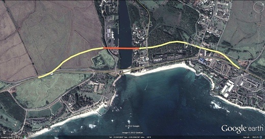
Image above: New mauka alignment of Kuhio Highway by Juan Wilson. Click to enlarge.
From south to north the new highway alignment would veer inland about halfway between the two access points on Leho Drive that are the entrances to Lydgate State Park. This would mean only the southern entrance to Lydgate would exist in the future and it would be the access to the park as well as the Aston Beach Resort Hotel and Smith's Marina. The highway would go mauka of the Malae Heiau and onto an elevated bridge that would pass 20' over the eastern end of the Smith's Marina.
The elevated bridge would then cross the Wailua River and be about a quarter of a mile long. The bridge would ramp down just west of the public kayak launch area to meet a new intersection with Kuamoo Road. Let's hope the engineering of such a solution would include plans light rail and non vehicular traffic as well. Past the intersection the new Kuhio Highway would parallel mauka of the Coco Palms Lagoon to align with (and take the place of) Apana Road. There it would create a new intersection with Haleilio Road.
Beyond Haleilio Road the Kuhio Highway would follow the existing cane road to the north and veer back to the current alignment of the highway before reaching the Kapaa Bypass intersection. This scheme would move the highway back about 650 feet from its present position next to the surfbreak, but that might conceivably be enough for the next century. However, even if it could pass through the gauntlet regulations and reviews would anybody have a line on $100 million in highway funds to get her done?
The worst case scenario is when the area where Kuamoo Road meets the Kuhio Highway is awash in the ocean. The resulting break in the ability to move traffic back and forth over the Wailua River would cut the island in two. Without a year round harbor or commercial airport on the east or north side of Kauai everywhere north of the Wailua River will be truly isolated from the rest of the island. Another set of problems are occurring along Kekaha Beach. They are now sandbagging along the highway inland of where the lifeguard station used to be. A new alignment of the Kaumualii Highway needs to be studied now. Global Warming is real. Global Warming has begun.
See also:
Ea O Ka Aina: Wailua Beach Erosion 6/13/12 .
By Juan Wilson on 26 August 2012 for Island Breath -
(http://islandbreath.blogspot.com/2012/08/wailua-beach-under-water.html)
Image above: A hole at the edge of Kuhio Highway opposite the Coco Palms hotel has started to appear in the vicinity where the waves are undermining an ironwood tree. From (http://thegardenisland.com/news/local/people-see-the-changing-face-of-wailua-beach/article_9614b31a-ecfd-11e1-bccc-001a4bcf887a.html).
There is a shoreline crisis at the mouth of the Wailua River. It may be part of a cyclical event but there are inevitable forces that point to a deteriorating situation at this critical point of traffic circulation that the whole island of Kauai depends on. Over the last several years the state Department of Transportation and the County of Kauai have spent tens pf millions of dollars to "fix" the traffic problems and add a bike path amenity.
The widening of the cane haul bridge over the river cost $29 million alone. Those investments may be a total loss in the next decade. The beach has eroded dramatically and now threatens the highway. The planned bike path between the highway and the beach may be unbuildable. Unfortunately, the huge amount of energy and fortune spent to widen the Kuhio Highway should never have been spent so close to the ocean. In a Garden Island News article on 8/22/12 titled "The Changing Face of Wailua Beach", it was reported:
Ruby Pap, the Coastal Land Use Extension Agent for the University of Hawaii Sea Grant College Program, stated;The facts on the ground are a fast dramatic erosion of the Wailua Beach endangering the existing highway and likely precluding the construction of a beach bike trail. As usual the state DOT was looking in the rear view mirror in its decades old plan to double up on the width of highways throughout Hawaii. Needless to say they did not see Peak Oil or Climate Change coming. They saw merely a steady growth of traffic as being business as usual.
“In the case of Wailua Beach, the long-term trend is accretion rather than erosion. Accretion means the beach has been growing over time. However, shoreline position is highly variable or episodic, which means there have been extreme episodic erosion events followed by a return of the beach.”She noted erosion has approached the road in the past (April 1975).
“The recent erosion, which is hopefully temporary, could be explained by the strong and consistent trades we’ve had recently. The Northeast trade swell could have driven sand to the south toward the river mouth.”She said this is an area that should be closely monitored to see if and when the beach comes back.
The TGI article went on to quote Dr. Chuck Blay, a geologist, naturalist and educator with The Edge of Kauai Investigations wrote;
“The situation at Wailua would have little to do with dredging of the river.”Blay said the shoreline is changing and will change significantly over the next 100 years with probably as much as a meter of sea level rise.
The tendency will be for the beaches to retreat landward as the water level rises and if such retreat is blocked by shoreline development such as sea walls, revetments, harbor developments, etc., then the beach will erode with the sand going somewhere else.
Had they been looking forward in time they would have looked to realign the Kuhio Highway mauka (away from the sea). This is difficult in the area of the Wailua River, but is going to be inevitable in the decades ahead. Complicating the issue is the rich cultural history of the Wailua area. The variety of sacred Hawaiian site is daunting. A quick study reveals a possible future alignment. This plan is only meant to get a conversation going. I realize there are many legitimate concerns raised by such a proposal.

Image above: New mauka alignment of Kuhio Highway by Juan Wilson. Click to enlarge.
From south to north the new highway alignment would veer inland about halfway between the two access points on Leho Drive that are the entrances to Lydgate State Park. This would mean only the southern entrance to Lydgate would exist in the future and it would be the access to the park as well as the Aston Beach Resort Hotel and Smith's Marina. The highway would go mauka of the Malae Heiau and onto an elevated bridge that would pass 20' over the eastern end of the Smith's Marina.
The elevated bridge would then cross the Wailua River and be about a quarter of a mile long. The bridge would ramp down just west of the public kayak launch area to meet a new intersection with Kuamoo Road. Let's hope the engineering of such a solution would include plans light rail and non vehicular traffic as well. Past the intersection the new Kuhio Highway would parallel mauka of the Coco Palms Lagoon to align with (and take the place of) Apana Road. There it would create a new intersection with Haleilio Road.
Beyond Haleilio Road the Kuhio Highway would follow the existing cane road to the north and veer back to the current alignment of the highway before reaching the Kapaa Bypass intersection. This scheme would move the highway back about 650 feet from its present position next to the surfbreak, but that might conceivably be enough for the next century. However, even if it could pass through the gauntlet regulations and reviews would anybody have a line on $100 million in highway funds to get her done?
The worst case scenario is when the area where Kuamoo Road meets the Kuhio Highway is awash in the ocean. The resulting break in the ability to move traffic back and forth over the Wailua River would cut the island in two. Without a year round harbor or commercial airport on the east or north side of Kauai everywhere north of the Wailua River will be truly isolated from the rest of the island. Another set of problems are occurring along Kekaha Beach. They are now sandbagging along the highway inland of where the lifeguard station used to be. A new alignment of the Kaumualii Highway needs to be studied now. Global Warming is real. Global Warming has begun.
See also:
Ea O Ka Aina: Wailua Beach Erosion 6/13/12 .
1 comment :
Another option is to restore the river crossing up mauka of the Experiment Station, connecting the Wailua Falls road (Maalo Rd.) to Kuamo`o. Solves the issue of all of Kapa`a town being at risk due to low elevation.
Post a Comment